

Around 155 miles north of the Philippines capital rests a foggy mountain town named Baguio City. This “City of Pines” features a climate cooler than the lowlands of the islands and a curious structure of winding roads, strawberry fields, and shaded hills. As an iconic tourist destination, domestic and international visitors tell of attractions like its golf courses and serene hiking paths, as well as the imposing Lion’s Head statue along Kennon Road. With its schools, such as the University of Baguio, and as the business capital of the region, Baguio is also home to locals and students alike.
What might be surprising, though, is that these romantic and inviting qualities obscure evidence of an imperial context in Baguio’s architectural and landscape design. The United States’ past struggle for legitimacy in the Philippines and as a world power is built into its terrain. Baguio’s popular tourist attractions, and the ways in which they were designed and constructed, remind us that historical power dynamics and hierarchies are represented and rearticulated in different mediums.
Benevolence and US Urban Design in the Philippines
During the onset of US occupation in 1900, the Philippine Commision, led by William Howard Taft, released a statement against calling the Philippines a colony. In this act, the commission had aimed to disconnect US involvement in the Philippines with colonialism. Instead, as detailed by a friend to Taft in a letter, the US “would give the people to believe that they had the responsibility to maintain order” by instilling a civic government. This paternalistic narrative of American responsibility had persisted from President William McKinley’s 1898 memorandum, which expressed the policy of benevolent assimilation of the Philippines upon the end of the Spanish-American War. The US occupation of the Philippines had been a first step into empire-building, and the islands represented the United States’ public bid for legitimacy as a world power.
Instilling civic authority, and thus fulfilling the promise of benevolent assimilation, required many projects, notably the construction of infrastructure and the resulting overhaul of architectural and landscaping aesthetics. In the first decade of rule, the US Insular Government had prioritized infrastructural projects such as expanding ports, building new roads and railroads, and erecting public structures like hospitals, markets, schools, and municipal buildings.
It was clear that the aesthetics of such projects were important because they symbolized American benevolence. W. Cameron Forbes, then recently appointed to the Philippine Commission as secretary of commerce and police, described his observations of Manila: “The office of the Insular Architect was a scandal...the result was that all of the government buildings...were done without the artistic eye and architectural sense that should be evidenced by a civilized people as an example in dealing with less civilized peoples.” Forbes held that the lack of aesthetic appeal of American architecture at the time called into question the legitimacy and intentions of US involvement in the Philippines, emphasizing the symbolic significance of the built environment in an imperial context. For instance, many of the new American buildings were constructed with reinforced concrete, as opposed to the tiled roofs built by the Spanish, which scholar Scott Kirsch argued to be a visual representation of the intensity of the presence of the United States as a colonial power. Indeed, the literal permanence of this concrete material reflects the purported goal to instill lasting American civic principles in the territory. The embellishment of these previously uninspired imperial buildings would then dress up the role of American influence: one of benevolence toward the “Little Brown Brother.”
From the Philippine Commission’s aesthetic focus emerged efforts to design and build a landscape that was distinctively American, coupled with a need for a retreat for unadjusted Americans living in the tropical climate of the Philippines. Advocates for this retreat turned to Baguio in Northern Luzon, known for its cool climate and mountainous terrain and located near a past Spanish Army garrison and sanitarium. To design this hill station, the commission recruited prominent architect and urban planner Daniel H. Burnham. Burnham would later comment that the redesigned Manila would represent the “destiny of the Filipino people” and “the efficient services of America in the Philippine Islands.”
Burnham was a proponent of the City Beautiful movement that aimed to better social problems produced by industrialization using space and the built environment. His architectural style relied on the Beaux-Arts movement and neoclassical, European architecture. He was especially excited for the Baguio project and shared in the 1904 Chicago Daily Tribune, “I shall be able to formulate my plans untrammeled by any but natural conditions. I shall...go ahead with the creation of a brand new city.”
Baguio and the Mateo Cariño Doctrine
But Baguio was, by no means, a blank map upon which Burnham could ink his plans. Cordillera indigenous peoples—referred to collectively as Igorots—had built dwellings from pine and rattan, topped by nipa roofs. Witnesses to these structures note that the houses were made for mobility wherein they could be disassembled and assembled without damage. In fact, this flexibility had granted Igorots a quality of “elusiveness” which frustrated Spanish colonizers. Indigenous ancestral land ownership over Baguio would similarly become a topic of contention for American occupiers wishing to establish the summer capital there.
The seizure of Baguio land led to a battle at the Supreme Court. Native Mateo Cariño, an Ibaloi chieftain, owned large swaths of what would become Baguio, and his family had lived on the land prior to the arrival of Magellan. It is also important to note that Cariño had aided Emilio Aguinaldo, president of the Filipino revolutionary government, which had threatened the authority of the US occupiers. This relationship attracted the attention of the American Insular Government of the Philippines. Before the US Supreme Court, the counsel for the Insular Government painted Cariño as a trespasser or “squatter” on the land, while Cariño’s attorneys cited the differences between Indigenous and Western laws and customs of land ownership. In the end, the Supreme Court ruled in favor of Cariño, recognizing his native title over the lands. The Mateo Cariño Doctrine, to this day, has been used to protect Indigenous ownership of ancestral land, such as in Canada, the US, and New Zealand. However, Cariño passed away a year before the landmark ruling, and his direct descendants had not benefited from the legal victory. On Cariño’s parcel of land, Burnham started his plans for the summer capital.
The Burnham Plan for Baguio & Attractions
Since Baguio was meant to serve as a retreat from American colonial labor, Burnham set out to harmonize country and city, striking a balance of public buildings, nature, and business. First, he laid out what is now known as Burnham Park, inspired by the design of the Washington, DC Mall. The City Hall rests on one end of the stretch of grass, with the Burnham Lagoon situated in the center with rowboats available for rent.


Burnham’s plan for Baguio reflected a cohesion of business, municipal structures, and leisure, but it also reflected hierarchy. In a 1905 draft report, Burnham illustrated that while all of these sectors are connected—an interweaving that is still present today—the group of American-established national buildings like the City Hall “nevertheless frankly dominate everything in sight of it.” Burnham had made use of the mountainous terrain to place government buildings at an elevation, facing each other and viewing the activities below.
Connecting Baguio to the surrounding Benguet province is a steep, winding highway named Kennon Road. Along the zig-zagging roadway, one can expect to witness the scenic Bued River Canyon and its mosaic of waterfalls, pine trees, and sunflowers.

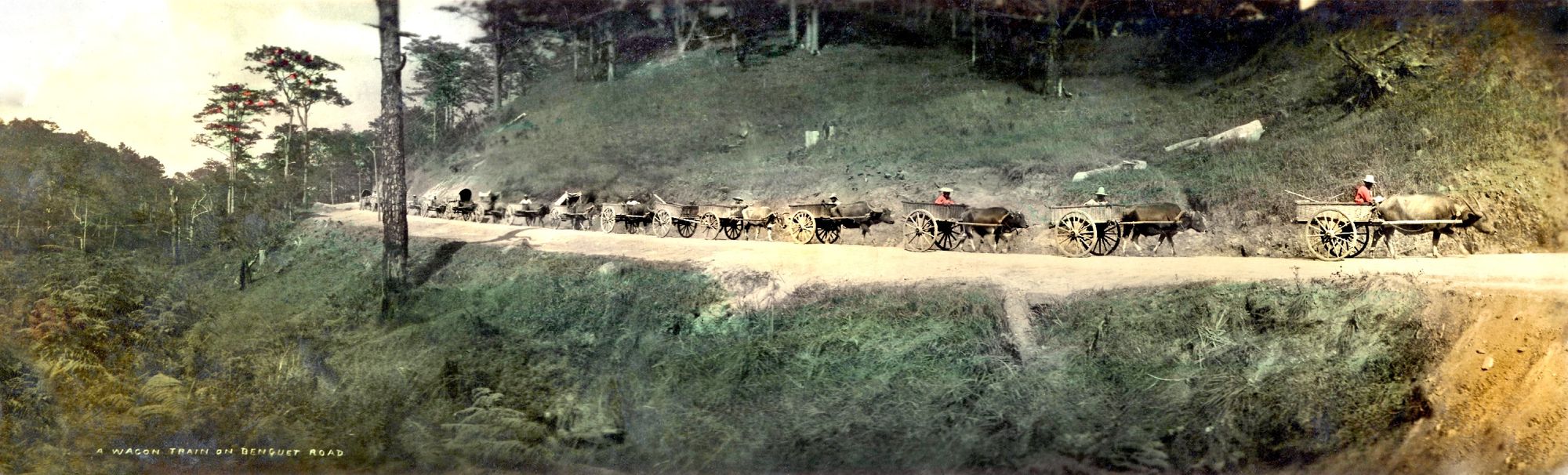
The building of Kennon Road, also called Benguet Road during construction, similarly reflected and rearticulated hierarchies along American-Filipino and racial lines. At first, Benguet Road required significant funding and maintenance, and Forbes was able to secure this investment in 1905. The first laborers were Indigenous Igorots. Civil engineer Captain Charles W. Mead, detailed the industriousness of the Igorot workers, claiming that they were “superior to any other natives”; cholera would soon infect the workforce, leading to many unsuccessful attempts to recruit more laborers.
As more Filipino laborers were recruited to build the winding road, a caricature of Filipino workers emerged, and the colonists wrote that they were indolent and lacked free agency. Members of the Philippine Commission argued, in an early, stereotyping invocation of the “colonial mentality,” under the Spanish, Filipino laborers worked out of obedience and not out of a motive to earn for themselves. The construction’s overseer, Lyman W. V. Kennon, paid, per day, American laborers US$1 to US$1.50, Japanese and Chinese laborers at US$1, and finally, 25 cents for Filipino laborers (though they had originally been recruited at 50 cents). Kennon justified this by saying Filipinos did not work as hard as Americans. Hundreds of laborers died in the process of building Kennon Road from illness and landslides. While Kennon Road would stand as a symbol of the lasting impacts of American colonization, the construction of such a symbol, too, required imperialist racial hierarchies.
To the east of Burnham Park, the teachers’ camp is a meeting place for conferences and other social functions sponsored by the government; namely, the Philippines Department of Education. It was established in 1908 for American educators who worked at the new US-backed public schools, and the project was initiated by Governor William Pack. Dean Worcester, who was the Secretary of the Interior of the Philippine Islands, reinforced the indolent Filipino stereotype, saying that “Americans who spend too many years in out-of-the-way municipalities of the Philippines without coming in contact with their kind are apt to lose their sense of perspective, and there is a danger that they will grow careless, or even slovenly in their habits.”
Camp John Hay, first established as an American military post and sanitarium in 1903, survived bombing from the Japanese Imperial Army in 1941, and then became a Japanese internment camp. Now a tourist attraction, Camp John Hay features a totem pole dedicated to the so-called “pioneers” of Baguio standing tall. Its erected heroes are W. Cameron Forbes, Daniel Burnham, William Pack, Lyman W. V. Kennon, Dean Worcester, and author Otto Scheerer, the first white man to welcome Americans to Baguio.
Perhaps, then, the Baguio pioneers’ totem pole fulfilled Burnham’s need to establish his legacy, his architecture acting as “enduring witness to the efficient services of America” in the Philippines. But, amid this rhetoric exists the reality of Baguio’s past: that it represents the contradicting narratives of American imperialism writ large. The period of American colonization of the Philippines was, on one hand, said to be defined by benevolence wherein Americans were the bringers of civilization and stability. This romantic justification inspired and thus permeated the physical construction of the leisure capital. On the other hand, Baguio reminds us that imperialism and all it requires—racial hierarchy, brutality, and paternalism—reproduces itself through many mediums, including through architecture and in the construction of a seemingly innocuous summer destination.
The cover photo, titled "Baguio City Post Card" by Fred Miller, is licensed under CC BY-SA 2.0.